On August 3, 1795, a line was drawn across Ohio that changed everything.
The Treaty of Greenville, negotiated between the United States government and a confederation of twelve Native American nations, established the boundary between American settlement and Native territory in the Northwest Territory. Everything west and north of that line belonged to the Native nations. Everything east and south of it was open to American settlement. It was one of the most consequential agreements in the history of the American frontier, and its effects shaped the landscape of Ohio for generations.
To understand the treaty you have to understand what came before it.
The World Before the Line
For thousands of years before European contact, the land that would become Ohio was home to a complex and diverse array of Native peoples. The Shawnee, Delaware, Wyandot, Miami, Ottawa, Ojibwe, Potawatomi, and others had established villages, trade networks, agricultural systems, and political relationships across this landscape long before the first European explorer set foot in the region.
The arrival of French and then British colonial interests in the 17th and 18th centuries disrupted those relationships profoundly. The fur trade, colonial warfare, and the steady pressure of European settlement from the east pushed Native communities into increasingly difficult positions. By the time the American Revolution ended in 1783 and the new United States began pressing its claims to the Northwest Territory, the Native nations of Ohio found themselves facing an existential threat to their way of life and their land.
They did not accept that threat passively.
The Wars for Ohio
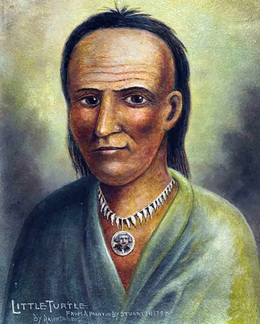
The decade following the Revolution was marked by sustained and deadly conflict across the Ohio frontier. American settlers pushing into the territory faced fierce resistance from a confederation of Native nations who understood clearly what American expansion meant for their communities. The United States Army suffered catastrophic defeats in this period. In 1791, General Arthur St. Clair led an American force of nearly 1,400 men into northwestern Ohio and was routed by a Native confederacy led by Miami war chief Little Turtle in what remains the single worst defeat ever inflicted on the United States Army by Native American forces. More than 600 soldiers were killed in a single morning.
It took three years and a rebuilt army under General Anthony Wayne to turn the tide. On August 20, 1794, Wayne’s forces defeated the Native confederacy at the Battle of Fallen Timbers near present-day Toledo. The battle itself lasted less than an hour. Its consequences lasted generations.
The Treaty
With the military defeat at Fallen Timbers, the Native confederacy lost its strongest bargaining position. Representatives of twelve nations gathered at Greenville, Ohio in the summer of 1795 to negotiate terms with General Wayne. On August 3rd they signed the agreement that bears the town’s name.
The treaty ceded approximately 25,000 square miles of Native territory to the United States, covering most of present-day Ohio and portions of Indiana. In exchange the Native nations received goods valued at approximately $20,000 and annuity payments. The boundary line established by the treaty ran diagonally across Ohio from roughly the mouth of the Cuyahoga River in the northeast to the mouth of the Kentucky River in the southwest.
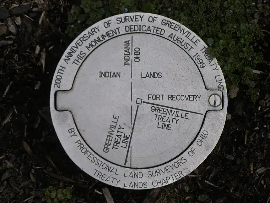
That line is known as the Greenville Treaty Line, and it is still visible in the landscape of Ohio today.
The Line in the Landscape
The Greenville Treaty Line was not an abstraction. It was surveyed, marked, and recorded. It became the legal and psychological boundary of the American frontier in Ohio for the years immediately following 1795. Settlers knew where it was. Land speculators knew where it was. The Native nations who had ceded land on one side of it and retained territory on the other knew where it was.
As American settlement pushed into Ohio in the years after 1795, the treaty line served as the organizing boundary of expansion. The Virginia Military District, established to compensate Virginia’s Revolutionary War veterans with Ohio land grants, was surveyed in the territory opened by the treaty. The townships and counties that formed in the early 19th century were shaped by the survey lines that followed in the treaty’s wake.
The line did not disappear when settlement moved past it. It became embedded in property boundaries, county lines, and road corridors across the state. It is marked today by Remarkable Ohio historical markers in several counties. In some places you can still follow it on foot through the landscape, reading it in the way survey boundaries shifted and property lines aligned along its diagonal path.
Why It Still Matters
Understanding the Greenville Treaty Line means understanding that the history of the Ohio frontier is not a simple story of empty land being settled by pioneers. It is a complex, layered, often painful story of nations in collision, of worlds being made and unmade, of lines drawn across landscapes that had been lived in and loved for thousands of years before the surveyors arrived.
The settlers who crossed that line in the years after 1795 were not moving into a blank space. They were moving into a landscape with deep history, contested meaning, and living memory on both sides of the boundary. The oldest residents of Ohio’s frontier communities when the first townships were organized would have remembered the world before the treaty. For them it was not ancient history. It was their lifetime.
That complexity is what makes the history of the Ohio frontier worth telling carefully and honestly. The treaty line is not just a surveying artifact or a legal boundary. It is the seam where two worlds met, and the story of what happened along that seam is one of the defining stories of American history.
It is a story we are committed to telling.